
Inventarisasi Data Keruangan Melalui Pemetaan Partisipatif Batas Desa Langlang Kecamatan Singosari Kabupaten Malang
Article Sidebar
Main Article Content
Abstract
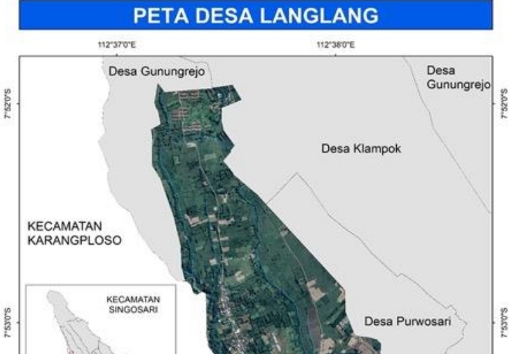
Langlang Village is a village in Singosari District with a strategic location close to the main route to Batu City and unique umbul potential. The aim of the service activity is to inventory spatial data through mapping Langlang Village. This service activity method uses a Rural Participatory Appraisal approach. The design of mapping activities in Langlang consists of 3 stages: the FGD stage, data collection training stage, and information presentation stage. Characteristics of participatory mapping include a) involving all members of the community, b) the theme, objectives, and process of implementing the mapping are determined by the community, c) the map produced is aimed at the interests of the community, d) most of the information contained in the map comes from local knowledge, and e) the community determines the use of the resulting map. Community service activities produce village maps containing geospatial information in the area. The use of maps is used as a guide in regional planning by local village officials and the community, providing community understanding and knowledge in understanding the characteristics of the region and its administrative boundaries.
Article Details

This work is licensed under a Creative Commons Attribution-ShareAlike 4.0 International License.

Jurnal Pemberdayaan Masyarakat is licensed under a Creative Commons Attribution 4.0 International License.
References
Anwar, M. Z., & Angga, R. D. (2018). Perempuan, Aset Desa, Dan Sumber Penghidupan: Studi Kasus Desa Gadungan, Blitar, Jawa Timur. Musãwa Jurnal Studi Gender Dan Islam, 16(1), 81. https://doi.org/10.14421/musawa.2017.161.81-96
Baharuddin, Refki, A., & Fuady, A. (2020). Participatory Mapping For Acceleration Of Village And Area Development In Tambak Sarinah Village , Kurau Sub District , Tanah Laut District. AQUANA,Jurnal Pengabdian Kepada Masyarakat, 1(2), 52–60.
Boissiere, M., Duchelle, A. E., Atmadja, S., & Simonet, G. (2019). Panduan teknis pelaksanaan pemetaan desa partisipatif. Center for International Forestry Research (CIFOR). https://doi.org/10.17528/cifor/007338
Cadag, J. R. ., & Gaillard, J. . (2012). Integrating Knowledge and Actions in Disaster Risk Reduction: The Contribution of Participatory Mapping. Royal Geographical Society, 44(1), 100–109.
Chambers, R., Sukoco, Y., & Nugroho, P. A. (2000). Participatory Rural Appraisal: Memahami Desa Secara Partisipatif. Kanisius.
Citra, I. P. A., & Sarmita, I. M. (2019). Pemetaan Potensi Wisata untuk Pengembangan Desa Wisata Muntigunung di Desa Tianyar Barat. Jurnal Widya Laksana, 8(1), 85–90.
Daniel, M. (2004). Sistem Kolaborasi Terpadu. Wacana.
Fisu, A. A., & Marzaman, L. U. (2018). Pemetaan partisipatif Kampung Pesisir Kelurahan Tallo Kota Makassar. To Maega: Jurnal Pengabdian Masyarakat, 1(1), 22–28.
Handayani, H., & Cahyono, A. B. (2014). Pemetaan Partisipatif Potensi Desa (Studi Kasus: Desa Selopatak, Kecamatan Trawas, Kabupaten Mojokerto. Geoid, 10(1), 99. https://doi.org/10.12962/j24423998.v10i1.705
Handayani, H. H., & Cahyono, A. B. (2014). Pemetaan Partisipatif Potensi Desa (Studi Kasus: Desa Selopatak, Kecamatan Trawas, Kabupaten Mojokerto. Geoid, 10(1), 99. https://doi.org/10.12962/j24423998.v10i1.705
Hasyim, F., Subagio, H., & Darmawan, M. (2016). One map policy (OMP) implementation strategy to accelerate mapping of regional spatial planing (RTRW) in Indonesia. IOP Conference Series: Earth and Environmental Science, 37, 012054. https://doi.org/10.1088/1755-1315/37/1/012054
Hilman, Y. A., Khoirurrosyidin, K., Nasution, R. D., Ramadhan, A. S., Robby, A. T., & Salsabila, T. N. (2023). Dinamika Upaya Inventarisasi Aset Desa di Desa Bungkal Kabupaten Ponorogo. Ganaya : Jurnal Ilmu Sosial Dan Humaniora, 6(3), 641–649. https://doi.org/10.37329/ganaya.v6i3.2520
Mardianto. (2016). Pemberdayaan Kelompok Informasi Masyarakat Dalam Mendorong Pembangunan Desa. Public Corner, 11(2), 1–16.
Muhsin, A., Nafisah, L., & Siswanti, Y. (2018). Participatory Rural Appraisal (PRA) for Corporate Social Responsibility (CSR) (1st ed.). Deepublish.
Prahasta, E. (2002). Sistem Informasi Geografis Konsep-Konsep Dasar. Informatika.
Rochdiyanto, S. (2000). Langkah-Langkah Pelaksanaan Metode PRA (Makalah ToT PKPI).
Samosir, H. T. W. (2020). Pemetaan Partisipatif, Kunci Keterlibatan Masyarakat Dalam Pembangunan Di Tingkat Tapak. WRI Indonesia.
Sulaksono, A. G. (2023). Implementasi Sistem Informasi Geografis pada Pemetaan Lahan Aset Desa Palembon menggunakan Google Maps API. Journal of Information System Research (JOSH), 4(2), 701–707. https://doi.org/10.47065/josh.v4i2.3022
Tallo, A. J. (2016). Participatory Mapping Solution Village Development Kerengas in a Sustainable Way. Seminar Nasional Peran Geospasial Dalam Membingkai NKRI, 139–148.